We conduct innovative and diverse research and development
based on top-tier research personnel and active investment.
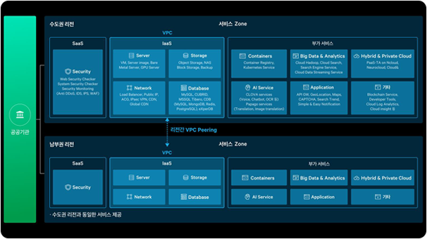
Naver Cloud Platform_Architecture Diagram
Naver Cloud Platform MSP
(Managed Service Provider)
AllforLand, as a Managed Service Provider (MSP) for Naver Cloud
Platform, offers a comprehensive range of "Cloud Infrastructure
Management Services," covering areas such as consulting, migration,
operation management, and security.
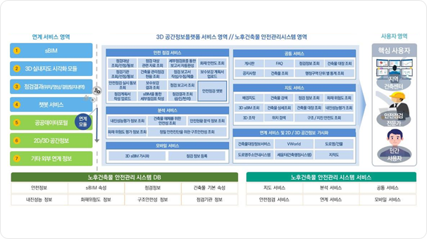
3D Geospatial Platform Integration
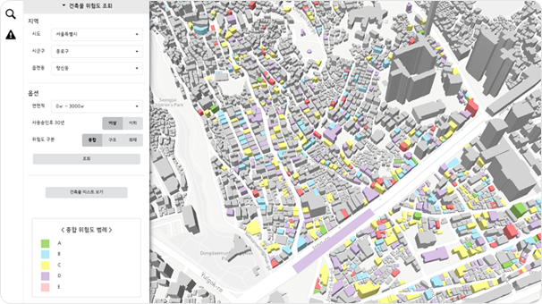
Building Risk Assessment
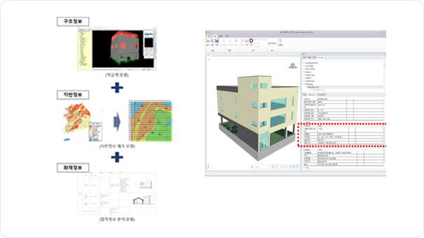
Engineering Prediction Model / Digital 3D sBIM (.ifc)
Cloud-based Digital Safety Management Framework
To establish a digital safety management system for aging buildings,
we design BIM-GIS-based system architecture and database architecture.
Additionally, we develop integrated safety management data operations
technology and technologies for linking with other system components.
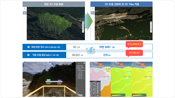
Digital Twin for Forest Resource Management
We design and develop a system that visualizes various geospatial data
and satellite big data databases on a digital twin platform, aiming to
support decision-making for national forest management.
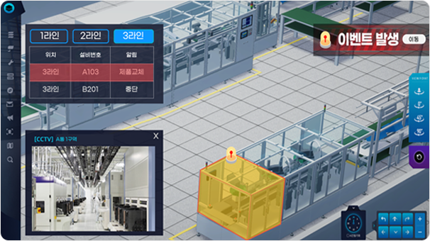
Virtualized Industrial Site Monitoring
Virtualized Manufacturing Process Monitoring Using Industrial IoT Data
We develop digital twin technology that represents actual indoor spaces,
equipment, and sensors of industrial sites in a virtual space, and create
a system that integrates and visualizes real-time industrial IoT data
within the virtual environment.
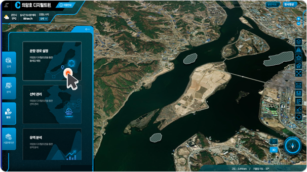
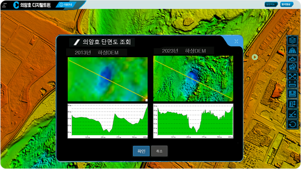
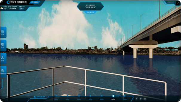
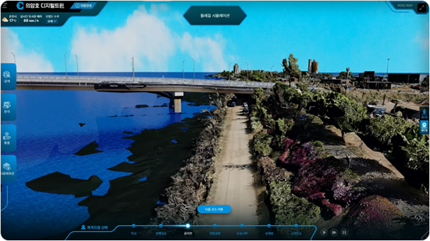
Lake Uiam Digital Twin
Digital Twin for Lake and River Basins
We develop digital twins for lakes and rivers to simulate changes in sediment
and water depth, and conduct research to establish a system that supports
decision-making through simulation analysis.
Main Information Security Certifications
Major Technologies
Development of Cloud-based Digital Safety Management Information System – Framework
Development of a Reference Model for Utilizing Building Safety Management Information
Basic System Architecture Design Reflecting G-Cloud and Latest Information Platform Technologies
Architecture Design for Supporting BIM-GIS Interoperability and Cross-Data Integration
Development of Indoor and Outdoor Integrated LOD Processing Technology for Building Safety Management Information
Major Technologies
TenserFlow를 이용하여 Mask R-CNN 모델 기반 예측 모델 학습 수행
항공 정사영상을 입력하여 학습된 예측 모델 기반으로 침엽수 및 활엽수 객체 검출
Major Technologies
농작물 탐지
산림수종 탐지
Major Technologies
Segmentation AI : 항공사진(드론 포함) 건물, 변화탐지, 자동차, 사람, 가로등, 구름, 빛반사, 양식장, 해양쓰레기 등의 객체를 탐지하는 AI
Inpainting AI : Segmentation AI 추론결과 또는 이미지에서 사용자 지정 영역을 지우는 AI
SuperResolution AI : 항공사진, 드론사진, 디지털트윈 객체를 대상으로 이미지의 초해상화 AI
Major Technologies
Development of a Digital Twin System Based on Unreal Engine for Forest Resource Management with Immersive Content
Implementation of a Digital Twin System Based on V-World and Visualization of Forest Resource Information
Development of Measurement Functions for Height, Distance, and Area on the Digital Twin Platform
Major Technologies
Development of synchronization technology for process-specific workflows, including space, equipment, and sensors, within the digital twin environment
Development of technology to integrate and visualize real-time industrial IoT data in a 3D virtual space
Development of technology for visualizing real-time IoT data such as operational status information for each piece of equipment
Development of time-series query functionality for process-specific digital twin systems using large-scale status data
Major Technologies
Sediment runoff simulation functionality
Functionality to review terrain changes due to sediment runoff and deposition on a 3D map
Trend analysis of water depth changes by point and location using depth measurement and expected depth data overlap
Real-time review functionality for water depth changes through water level designation
Display of safe navigation zones and simulation of navigation routes based on water depth changes
Foundational technology for landslide analysis simulations